View GPX file on map + elevation
This page allows you to display a track from a GPX file recorded with your GPS (using maplorer or any other software writing GPX files, which is pretty much standard).
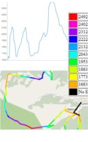
The elevation profiles are displayed based on Google Maps and the content of your file (if it has valid ELE tags).
You can also use the tool to plan a route by adding waypoints - just click on the map and the elevation profile will be updated.